Blurred Edges
- Veeravalli Vikram, Dipti Bhaindarkar, Sabaa Giradkar and Rohit Mujumdar
- Mar 15, 2020
- 5 min read
A Tale of Two Lakes – Powai and Vihar
Semester 6 | Settlement Studies
Studio Mentors : Rohit Mujumdar, Sabaa Giradkar, Malaksingh Gill, Ravindra Punde, Dipti Bhaindarkar
-Veeravalli Vikram, Dipti Bhaindarkar, Sabaa Giradkar and Rohit Mujumdar
Architectural Representation and drawing have been a subject of discussion over the past few years. The quest to rethink existing modes of drawing and detailing to convey ideas has been at the forefront of architectural thinking. Why should we stick to drawing buildings in orthography when it is just one of the recent concepts to enter the framework of representation? How were buildings made in the past, before orthographic projection drawings were initiated? What other methods hold the key to reimagine and reshape architectural thought so that new forms of space could be developed? The Semester 6 Settlement studies module aimed to open up the idea of visualizing the edge of water and land, the line between water and land through a study of wetness and lake precincts.
Dilip da Cunha, an architect, planner and an environmentalist, puts forth an important argument that provokes new ways of thinking and representation. He suggests a different lens of looking at spaces that breaks away from practices of drawing hard lines and edges to represent spaces. He introduces the idea that there is ubiquitous wetness and that everything in this world could be seen through varying degrees of wetness – water being extremely wet and solid material like sand being less wet and so is the land which is less wet. One then has to think of other ways of representing this idea that doesn’t create rigid boundaries and differentiates land and water as we do now.
The two lakes of Powai lake and Vihar lake in the city of Mumbai formed the entry point of this study. The goal was to explore the edge conditions of these lakes and their surroundings and how their wetness affects everything in the vicinity. Powai lake is at the heart of the city with dense urban settlements on all sides whereas Vihar lake is embedded into the forest area of Sanjay Gandhi National Park with restricted access. The focus of the study was narrowed down to certain zones around the lakes. Around Powai lake, the sites studied were the IIT Bombay premises and the Hiranandani complex. Around Vihar lake, it was the western edge near the origin of Mithi river and the eastern edge along the pipeline road that leads to the water treatment plant at Bhandup. The module progressed as a game theory where the goal was to identify different actors and their involvement in the game. The students then dawned the roles of these actors and explored their influence on the site and their aspirations for it. The aim was to extract as much information as possible and to convert it into knowledge that would be shared with the rest of the groups to collectively decide on the programme. Some of the common actors identified at each of the sites were the corporators, real estate people, environmental activists, administration, residents of settlements, flora, fauna and important landmarks as well. The secondary goal was to create a map of wetness for each site and explore different narratives that would shape the map and eventually explore the way it is made. The first step to start the process was to conjecture sections through the transect of the site to understand the relationship of the lake with its surrounding terrain.
Group Members |SHARMA ANKIT, DESAI ADWAIT, NAIK RITU, PRANAY KOTADIA, RANGNEKAR RAUNAK
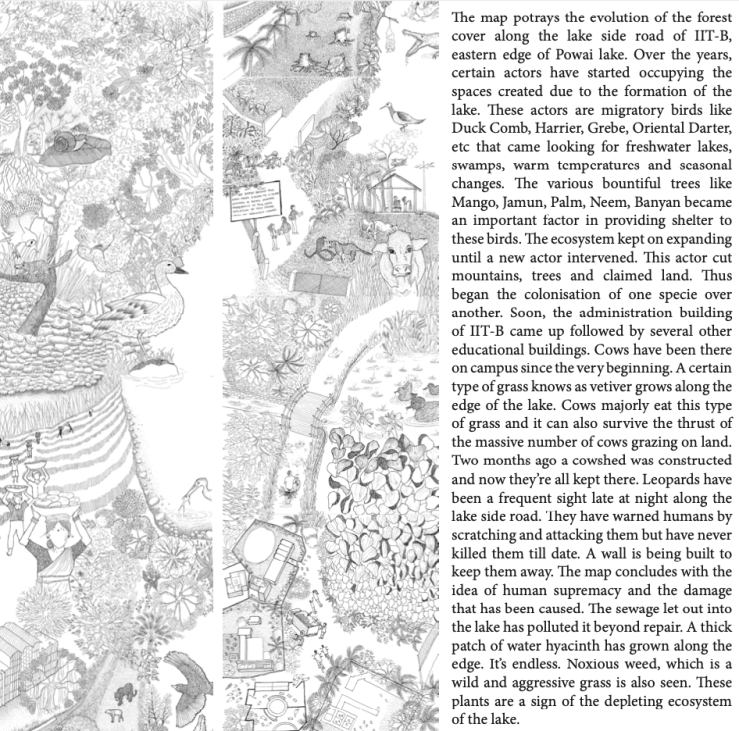
At IIT Bombay, some of the aspects studied were the relationship of the campus with the lake ecosystem and their interdependence. Many studies of the lake over the years, conducted by government and private establishments have hinted towards the declining water quality. How do the people at IIT react to and process this information? The stakeholder here was the administration that possesses a certain power over the rest of the actors due to the site being part of an institution. The edge condition was a spread of institutional buildings, hostels, guest houses, cowsheds, water hyacinths, algae and a boathouse. It would be interesting to navigate the hierarchy of the actors, their roles and powers to process the information.
SITE | IIT BOMBAY
Group Members |AGARWAL ANJALI, DHAMAPURKAR AKSHADA, GANDHI CHINMAY, JOSHI NANDITA, MALI RITHIK, NADKARNI SOMESH, PATIL MADHURA, RANGNEKAR RAUNAK, SARVAIYA RUCHITA, THAKKAR DEVANSHI
At the Hiranandani complex, one of the lenses of viewing the site was through layering and how the density of actors keeps decreasing as one moves farther away from the lake into the highly secure complex. The edge condition was that of the promenade on the southern side of the lake, which converted the soft edge of the intertidal zone into a rigid one and how it also increased the growth of algae and hyacinths. One of the active actors on-site was the Angling Association that strives to protect the lake ecosystem from being concretized. The highly commercial and urban nature of the Hiranandani complex stands in contract to the natural setting of the lake.
SITE | HIRANANDANI PRECINCT
Group Members | AKRE KSHITIJA, DESAI ADWAIT, GUPTA RAGHAV, KAMALIA JUGAL, MEHTA GRISHMA, NAHAR AMAN, NERKAR ABHISHEK, SARAF NIKEITA, SAWARDEKAR PRACHETA, SONI RONAK
At the western side of Vihar lake, the areas of study were the Vihar Udhyan, two settlements (Ultan pada and Sahi Bangoda) and a forest zone. The actors included the people at the settlement whose livelihood depended on the lake (through fishing), the wildlife, dogs, flora and specific community people. To build up the knowledge, it also required an understanding of the history of the settlements and their relationship with the lake. The map of wetness focused on the difference in the activities along the transect during summer and monsoon.
SITE |VIHAR LAKE WESTERN EDGE
GROUP MEMBERS |AMBHIRE ABHILASHA, CHAVAN RIDDHI, HABDE SANJANA, KESHARI NEHA, KUDTARKAR ANJAN, MISTRY VAIBHAV, PATIL ABHILASHA, RATHOD HIMANSHI, SHARMA ANKIT, SOLANKI PARTH
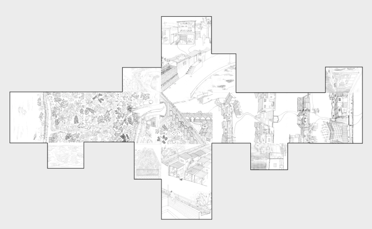
At the eastern side of Vihar, the edge condition observed was that of an old aqueduct from the British colonial era which has now been converted into a thick wall that separates the forest area near the lake and the settlements on its east. The forest area and the pipeline road on the edge of the lake is controlled and maintained by the Hydraulic department of MCGM and is highly restricted, making it an important actor. The aqueduct itself tells an important story through time and the history of people occupying areas near it. Some of the people at the settlements near it (such as Tembhipada) claim they do not know Vihar lake by name but are aware of its presence through the wetness in air. Some of the other actors include the shakha pramukh, the children, the elderly, the slum rehabilitation area inhabitants, the dense vegetation on the edge of the lake and the fauna. The map of wetness is centred at the junction where the forest, the settlement and the aqueduct meet.
SITE |VIHAR LAKE EASTERN EDGE
GROUP MEMBERS | CHANDAK MANTHAN, DOSHI HELEE, JAIN ALISHA, KOTADIA PRANAY, MEHTA NIDHI, NAIK RITU, PATIL YAMINI, SARANG GAURI, SHAH STUTI, VEERAVALLI VIKRAM
The module culminated with a preliminary understanding of mapping wetness and the narratives of each site. These lenses of spatial thinking allow room for interpretation which can be developed through a longer period of engagement, study and observations.


Comments