
PASHUPATINATH TEMPLE
Situated on the banks of the Bagmati river, the Pashupatinath temple is located in the town of Deopatan, surrounded by many other significant shrines and temples. Mythologically, Deopatan is considered to be the abode of Shiva, hence there are many shrines dedicated to Shiva and his various Avatars in the area. The temple is a part of the UNESCO World Heritage site, listed in 1979, which extends around 2460 sq.m. and includes more than 500 smaller temples, ashrams, statues, and inscriptions within the complex. The temple has a long history dating back to the Lichhavi period (450-750 CE) and the Malla dynasty (1201 - 1779). The oldest structure recorded was in 400 CE, which had a central lingam with a simple wooden temple built around it. After multiple alterations and renovations, the form we see today was built during the Malla rule in the 16th century, which blended the Indian Shikhara and Nepalese Pagoda styles of temple architecture.
Among many temples and shrines, the Pashupatinath temple stands out due to its two-tiered copper roofs covered in gold. The temple has a typical square plan with the innermost layer as the sanctum sanctorum where the lingam is placed, and the outer layer being the circumambulation path, all decorated with intricate carvings around the temple. While the temple was safe from the damage caused by the 2015 earthquake, many other shrines in the complex faced the aftermath.
Just like the temple has been transformed over the years, the surrounding area has also changed. Initially, the area around the Pashupatinath temple was a residential zone with fewer temples and basic infrastructure. Around 2013, as the temple complex began to grow, more spaces were added to accommodate people during various festivals and ceremonies and also cater to their parking requirements. As a result, the residential area on the south of the temple was reduced and the people were relocated to the main city. Subsequently the temple premises kept increasing and the space around was cleared to make more space for vehicles.
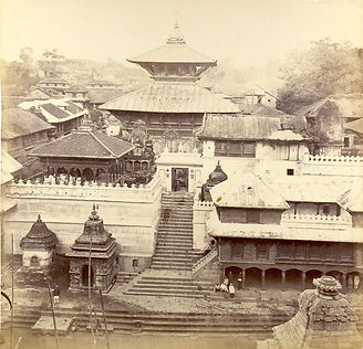
Pashupatinath temple in 1863
(Source: Rare Book Society of India | After British Library)
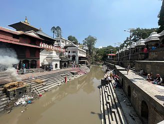
Bagmati River and the temple in the backdrop
(Source: Rupali Gupte)
This shift in land use is very clearly shown in the figure below, in a span of ten years from 2003-2023. In spite of efforts to modernise by providing updated facilities, the temple complex still follows the traditional hierarchies of caste and religion, questioning the role of architecture as an instrument of segregation.
References:
-
Hutt, Michael. 2010. Nepal: A guide to art and architecture of Kathmandu valley.
-
Bhattarai, Karuna. 2023. “Pashupatinath Temple, Facts, History, Attractions, Timings, Entry Fee.” Altitude Himalaya. https://www.altitudehimalaya.com/blog/pashupatinath-temple
-
“Pashupati area pays for the Trust's neglect.” 2023. The Kathmandu Post. https://kathmandupost.com/kathmandu/2023/03/27/pashupati-area-pays-for-the-trust-s-neglect
-
Nyaupane, Pashupati. 2019. “Cultural Heritage Tourism Management in Pashupatinath Area”. Nepalese Culture 13 (December):95-106. https://doi.org/10.3126/nc.v13i0.27504

Surrounding context of the Pashupatinath Temple
(Source: Drawn by Grishma Karle (Student, SEA) | After Surendra Joshi and Niels Gutschow)


